Hike at a Glance
Max elevation: 1000m
Min elevation: 602m
Total Ascent: 787m
Hike overview
The Macedon Ranges Walking Trail offers a 19-kilometre journey through the heart of Macedon Regional Park, taking hikers on a rewarding six-hour adventure. Starting from the Mount Macedon Hotel, the trail begins with a simple stroll along a bitumen road. Not long after, the road transitions to gravel, where you’ll find the official trailhead on your right. From here, the path starts its gentle climb up Mount Macedon, gradually winding its way through the forest.
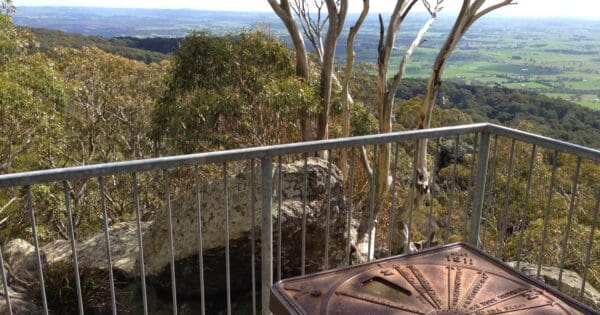
The first section of the trail is a series of steep, zig-zagging paths that stretch over a kilometre. While the incline may leave you needing to catch your breath, the effort is well worth it. Brief glimpses of the surrounding landscape appear between the trees, offering hints of the sweeping views to come. As you continue towards the summit, the forest begins to open up, and eventually, the trail leads you to the iconic Memorial Cross. From here, you’ll be treated to panoramic views of the Macedon Ranges and the valleys below.
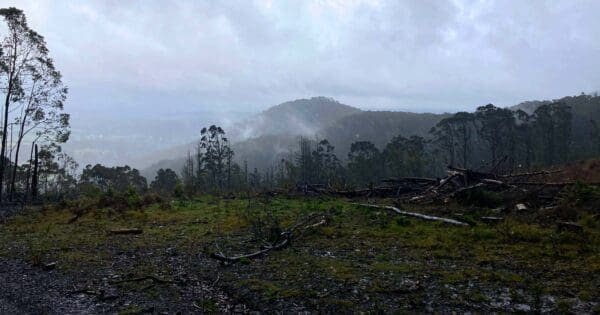
Beyond Memorial Cross, the trail flattens out as it follows the western face of Mount Macedon. This section is more relaxed, winding through messmate forest—some of which still bears the scars of fires that swept through the area two decades ago. As you move through this quiet landscape, you’ll pass several fire trails before reaching McGregors Picnic Ground. This shaded area, surrounded by towering European trees, provides an excellent spot to pause for a well-earned break.
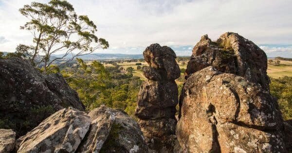
After lunch, the trail continues with a climb towards Camel’s Hump. Once you reach the carpark, it’s just a short walk to the summit. The views from Camel’s Hump are truly breathtaking, offering a fresh perspective of the park’s sprawling terrain. From here, you can either retrace your steps back to the junction or take a more adventurous route, following coordinates down through rocky outcrops to pick up the trail below. This off-trail section reveals some stunning rock formations, making the extra effort well worth it.
Back on the main trail, the path winds through dense forest before leading to Sanatorium Lake. Created in the 1800s to supply water to the nearby tuberculosis sanatorium, the lake now provides a serene habitat for local wildlife, including flame robins, swamp wallabies, and white-faced herons. Take a moment to enjoy the calm of the lake before continuing your hike.
From the lake, the trail descends gently along open fire trails before beginning the short but steep climb up Mount Towrong. The summit is marked by a large rock cairn, which offers another opportunity to take in the surrounding views. The descent from here is steep and rocky, so be sure to take your time and enjoy the vistas as the trail leads you through an open, forested section of the park. As you descend into the valley, the trail becomes more rugged, with stairs to assist your journey.
Eventually, you’ll reach a road, where you’ll turn left and follow a gravel road through residential streets. This final stretch brings you back to the Mount Macedon Hotel, where your hike concludes. The combination of challenging climbs, scenic views, and moments of tranquillity makes the Macedon Ranges Walking Trail a memorable experience for any avid hiker.
Tips
- Enjoy a varied hike with ever-changing scenery, from lush forests to open views.
- Hiking poles are recommended to help with stability on both ascents and descents.
- Bring at least 2 litres of water to stay hydrated throughout your hike.
- Pack enough food to maintain your energy levels during the trek.
Track grade
Grade 3 (Moderate) - Walks for Most Fitness Levels: Grade 3 on the AWTGS represents moderate walking tracks. These are ideal for walkers with some fitness who are comfortable with some hills and uneven terrain. While suitable for most ages, some bushwalking experience is recommended to ensure a safe and enjoyable experience. Tracks may have short, steep hill sections, a rough surface, and many steps. The total distance of a Grade 3 walk can be up to 20 kilometers.
Walk map and GPX file
Max elevation: 1002 m
Min elevation: 601 m
Total climbing: 794 m
Total descent: -799 m
Content use
Please don’t copy GPX files or content from this site to AllTrails or other platforms. Each trail has been personally mapped, documented, and refined to support Australia’s bushwalking and hiking community. While some details come from land managers, every listing reflects significant personal effort. This is a free, community-driven initiative—your respect helps keep it that way.
Getting there
Getting to the trailhead: Macedon Regional Park.
Reaching the trailhead at Mount Macedon Hotel, located at 694 Mount Macedon Road, Mount Macedon, VIC 3441, is straightforward. From Melbourne, head northwest on the Calder Freeway (M79) towards Bendigo. Take the exit for Macedon/Mount Macedon Road (C322) and follow the signs leading to Mount Macedon. Continue along Mount Macedon Road for approximately 5 kilometres until you arrive at the hotel on your left. The hotel serves as the starting point for the Macedon Ranges Walking Trail, making it a convenient spot to begin your hike.
Need a rental car to get you to the hike? Find one here.
Find a place to stay
Wondering where to stay near this hike? Find accommodation close to the trailhead — hotels, cabins and campgrounds nearby. Click the button to view the interactive map.
Closest towns to this walk: Bacchus Marsh, Gisborne, Kyneton, Lancefield, Macedon, Mount Macedon, Romsey, Toolern Vale, Woodend
Let someone know
Heading out? Fill in a trip intentions form so someone knows your plans. If things go wrong, they can raise the alarm fast, giving you peace of mind on the trail.
About the region
Just an hour north-west of Melbourne, Macedon Regional Park offers a peaceful and easily accessible escape into nature. Nestled within the southern reaches of Victoria’s Great Dividing Range, the park is part of an Aboriginal cultural landscape that includes the traditional Country of the Wurundjeri Peoples. It’s important to acknowledge the enduring relationship that Traditional Owners have with these lands and waters, and their role in caring for Country across generations.
The park’s rich blend of forested trails, historic landmarks and quiet picnic grounds makes it ideal for day-trippers or those looking to stay a little longer in the nearby towns and villages of Macedon and Woodend. Whether you’re drawn to walking tracks that wind through tall eucalypt forests, or scenic drives leading to sweeping viewpoints, there’s a gentle rhythm to exploring this region that invites you to slow down and take it all in.
A great starting point is the Sanatorium Picnic Ground, where you can enjoy a relaxed meal beneath the canopy before setting off on the shady loop around Sanatorium Lake. The Macedon Ranges Walking Trail threads its way through parts of the park, offering longer bushwalks for those keen to stretch their legs and spend more time immersed in the landscape. Autumn brings a special kind of magic here—the air crisp and cool, the surrounding hills alive with gold and crimson leaves. It’s worth finishing the day with a warm drink at the Top of the Range tea rooms, where the view and atmosphere offer a quiet moment to reflect.
The Mount Macedon War Memorial Cross is a powerful and prominent feature of the park. Standing at 21 metres high, it commemorates those who served in all wars and is the second most significant war memorial in Victoria after Melbourne’s Shrine of Remembrance. It draws visitors not only for its meaning, but also for the views across the plains below.
For those exploring on horseback, the Old Scout Camp area offers a good starting point, with float parking available nearby at the Days Picnic Ground. Riders need to stick to defined roads and tracks, as horses are not permitted on walking trails or within picnic areas. Cyclists will also find opportunities to explore—multi-use trails in the Old Scout Camp area range from gentle routes to more challenging terrain, while a network of open roads allows for broader discovery of the park and its surrounding countryside.
Camel’s Hump is the highest point in the Macedon Ranges and a favourite among experienced rock climbers. The volcanic plug rises sharply from the forest, offering impressive views and a range of climbing routes. Rock climbing is permitted only within a designated area and should be approached with care, using the proper access tracks and equipment, ideally under the guidance of qualified instructors.
For those preferring a more relaxed pace, the park’s scenic drives meander through tall forests, past picnic spots and up to elevated lookouts. Both sealed and unsealed roads provide access to many parts of the park, though some of the latter may be closed seasonally. It’s a lovely way to take in the natural beauty of the region without straying too far from the car.
Whether you're walking, riding, cycling or simply enjoying the stillness of a forest picnic, Macedon Regional Park has something to offer in every season. It’s a place where nature, history and culture sit side by side—welcoming visitors into a landscape shaped by both time and tradition.
Similar walks nearby
Looking for more walks in or near Macedon Regional Park? Try these trails with a similar difficulty grade.
Explore safe
Plan ahead and hike safely! Carry enough water, pack layers for changing conditions, and bring safety gear like a torch, PLB, and reliable communication device. Check official sources for trail updates, closures, and access requirements, and review local weather and bushfire advice. Most importantly, share your plans with someone before you go. Being prepared makes for a safer and more enjoyable hike! Stay Safe, Explore More, and Always #ExploreSafe.
Packing checklists
What you carry in your pack depends on factors like weather, terrain, and your adventure type. Not sure what to bring? My free planning, food, and packing checklists are a great starting point, covering day hikes, overnight trips, and multi-day adventures. Use them to customise your kit and always prioritise safety.
Suggest an edit
Notice something different about this trail? Whether it’s a new feature, a route change, or a closure, share your update so we can keep our info accurate and helpful for fellow hikers.
Click to suggest edits >>
Acknowledgement of Country
Trail Hiking Australia acknowledges the Traditional Owners of the lands on which we hike and pay respects to their Elders, past and present, and we acknowledge the First Nations people of other communities who may be here today.
/Macedon-Ranges-Walking-Trail_10.jpg)
/Macedon-Ranges-Walking-Trail_26.jpg)
/Macedon-Ranges-Walking-Trail_29.jpg)
/Macedon-Ranges-Walking-Trail_3.jpg)
/Macedon-Ranges-Walking-Trail_8.jpg)
/Macedon-Ranges-Walking-Trail_17.jpg)
/Macedon-Ranges-Walking-Trail_27.jpg)
/Macedon-Ranges-Walking-Trail_35.jpg)
/Macedon-Ranges-Walking-Trail_18.jpg)
/Macedon-Ranges-Walking-Trail_33.jpg)
/Macedon-Ranges-Walking-Trail_4.jpg)
/Macedon-Ranges-Walking-Trail_28.jpg)
/Macedon-Ranges-Walking-Trail_37.jpg)
/Macedon-Ranges-Walking-Trail_16.jpg)
/Macedon-Ranges-Walking-Trail_19.jpg)


5 Reviews on “Macedon Ranges Walking Trail (19km)”
A great day hike if you’re reasonably fit. The views were great and the trails ranged from roads through to rough and uneven stone steps. The views/features were also nicely spaced out across the whole walk so it kept me interested for the entire trip. I did very much appreciated my trekking poles on the steeper sections at the beginning and end. Timewise, it took me just under 5 hours, including breaks and getting into and out of my rain jacket and putting gloves off and on (it was cold and spitting that day). I felt like I was maintaining a pretty good pace (I passed many people on the way at least, and nobody passed me anyway).
I also found that the people in and around Macedon were very friendly and talkative which was a pleasant surprise, as I’ve never hung around long enough in the area to actually talk to anyone before. The Memorial Cross itself is not currently visitable, but you don’t have to take the detour anymore, so 99% of the track is as presented here.
That is a great circuit. Great views and plenty of varying scenery and bush along the way. Can get a bit busy especially around the picnic areas but it’s not long until you feel lost in the bush again. Highly recommended
Fantastic hike with a lot of variation including steep sections, open woodland, lakes and a few rocks to scramble around.
Awesome. Loved it. Very comfortable walk just over 4hrs. With a friend who trains on this track frequently. She gave me her poles for the final descent in the dark with headlamps.
Lovely trail not too far from Melbourne with a satisfying climb to the cross to start off with! Most walkers that I came across were doing sections of the Macedon Ranges Walking Trail and joined in from one of the several picnic grounds that this trail passes. The descent from Mt Towrong towards the end is a little steep and it pays to be sure-footed here as some loose rocks abound. Some brief sections on road had tight corners / potential blind spots – keep an eye out for cars if walking on public holidays / weekend.