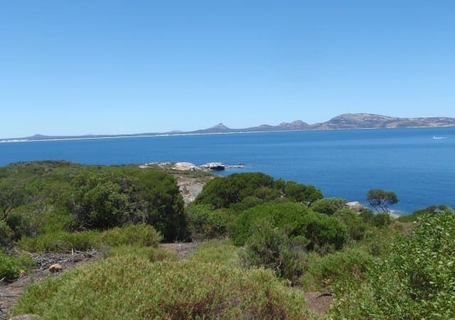
Len Otte Nature trail is a moderately easy one kilometre loop walk in Cape Arid National Park. This nature trail was designed and established in 1979 by Len Otte, the first resident ranger at Cape Arid National park. It was the first nature trail in any Western Australian national park and following his unexpected death, was dedicated as a fitting tribute to Len's achievements and life at the park.
The walk winds through woodlands and thickets up Belinup Hill (66 metres), showcasing the tremendous variety of plants in the area. Enjoy seasonal displays of yellow hibbertia, scarlet honeymyrtle and the golden southern plains banksia. There are also views across coastal heathland to Thomas River and Yokinup Bay. Walk trail surface consists of natural pavements made up of rock material including exposed granite and gravel. Sections of the walk were burnt by wildfire in November 2015.
Start Point: Cape Arid National Park, 125km (1.5 hours) east of Esperance, Thomas River Road
End Point: Cape Arid National Park, 125km (1.5 hours) east of Esperance, Thomas River Road
Region: Cape Arid National Park, Golden Outback
For more information, a location map and GPS file please visit Trails WA.
Got some great shots from this hike? Upload your photos here to inspire others and show off the beauty of the trail!
Uploading your photos doesn’t mean you lose ownership. You can be credited for your contributions, and you can request removal at any time.
Please don’t copy GPX files or content from this site to AllTrails or other platforms. Each trail has been personally mapped, documented, and refined to support Australia’s bushwalking and hiking community. While some details come from land managers, every listing reflects significant personal effort. This is a free, community-driven initiative—your respect helps keep it that way.
It looks like I don’t have a GPX file for this trail yet. If you have one to share, please email it to me! I’ll verify it against official maps before adding it to help other hikers have a safer, easier experience. Thanks for contributing to a better hiking resource.
Getting there
Getting to the trailhead: Cape Arid National Park.
Closest towns to this walk: Cape Le Grand, Condingup, Esperance, Munglinup, Nornalup, Ravensthorpe, Salmon Gums, Salmon Gums Balladonia, Scaddan Balladonia
About the region
Cape Arid National Park is a wildly beautiful and biodiverse area. Coastal sandheaths, mallee and low granite hills extend inland to Mount Ragged after which the vegetation is transformed into woodlands dominated by saltbush and bluebush. The jagged Russell Range, which rises to its highest point at Tower Peak (almost 600m), comprises ancient uplifted quartzite that has the same origins as the Barrens Range in Fitzgerald River National Park.
Similar walks nearby
Looking for more walks in or near Cape Arid National Park? Try these trails with a similar difficulty grade.
Favourite

Woody Island Nature Reserve
Favourite

Woody Island Nature Reserve
Favourite

Fitzgerald River National Park
Favourite

Fitzgerald River National Park
Track grade
Grade 3 (Moderate) - Walks for Most Fitness Levels: Grade 3 on the
AWTGS represents moderate walking tracks. These are ideal for walkers with some fitness who are comfortable with some hills and uneven terrain. While suitable for most ages, some bushwalking experience is recommended to ensure a safe and enjoyable experience. Tracks may have short, steep hill sections, a rough surface, and many steps. The total distance of a Grade 3 walk can be up to 20 kilometers.
Explore safe
Plan ahead and hike safely! Carry enough water, pack layers for changing conditions, and bring safety gear like a torch, PLB, and reliable communication device. Check official sources for trail updates, closures, and access requirements, and review local weather and bushfire advice. Most importantly, share your plans with someone before you go. Being prepared makes for a safer and more enjoyable hike! Stay Safe, Explore More, and Always #ExploreSafe.
Packing checklists
What you carry in your pack depends on factors like weather, terrain, and your adventure type. Not sure what to bring? My free planning, food, and packing checklists are a great starting point, covering day hikes, overnight trips, and multi-day adventures. Use them to customise your kit and always prioritise safety.
Let someone know
Before heading out, take a moment to fill out your trip intentions form. It’s a quick way to share your hike details with family or friends. If something goes wrong, they can notify emergency services, ensuring a faster response and peace of mind. Stay safe and enjoy your adventure
Suggest an edit
Spotted a change on this trail? Maybe there are new features, the route has shifted, or the trail is permanently closed. Whatever the update, I’d love your input. Your feedback helps fellow hikers stay informed and ensures that our trail info stays fresh and reliable.


