Laurieton track is a 3km, grade 4 hike located in Dooragan National Park, New South Wales. The hike should take around 1.25 hours to complete.
Hike overview
Laurieton track is a challenging walk on a rough trail, perfect for the intrepid adventurer. It's easily accessible, quickly transporting you from the bustle of life in Laurieton and Port Macquarie to the serenity of the forest full of wonderful wildlife.
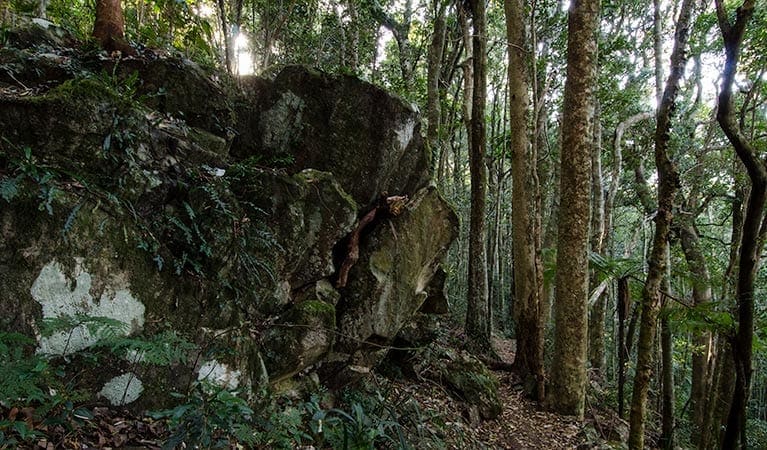
The trail heads through burly, towering blackbutt and eucalyptus forest, making it easy to reflect back on a time when these forests provided the timber lifeblood for the growing community of Laurieton. Some of the enormous old stumps are still there between the regenerating forests, remnants of this pioneering past.
Those preferring a less strenuous outing will find Rainforest loop equally enjoyable. This relaxed trail heads through cloud-formed subtropical rainforest, and is a great introduction for people with limited bushwalking experience.
Take a virtual tour of Laurieton track captured with Google Street View Trekker.
Route and GPX file
Help fellow hikers navigate with confidence. Share your GPX or KML file for this trail and help build a more comprehensive resource with precise waypoints and elevation profiles. Your contribution will empower adventurers with details they need for a safer and more enjoyable experience. I meticulously verify every file using official maps and surveys, ensuring the highest level of accuracy and reliability. Submit your file now and become a trailblazer for your fellow outdoor enthusiasts.
Tips
Remember to take your binoculars if you want to birdwatch
There is some mobile phone reception in this park
Visit NSW National Parks and Wildlife Service for more information on this trail.
The longitude and latitude of the start and end points are approximately only and should not be used for navigation purposes. Please contact me if you know the correct coordinates.
Trail location
Sorry, no records were found. Please adjust your search criteria and try again.
Sorry, unable to load the Maps API.
Getting there
To Captain Cook Bicentennial Drive. Laurieton track is in Dooragan National Park. To get there:Go through the council park on Laurie Street and onto the fire trail behind the houses. 250m northwest along the fire trail, you'll reach a narrower section of walking track. 70m along the walking track, you'll cross a little suspension bridge sectionAt a midpoint, about two-thirds the way up Captain Cook Bicentennial Drive, the walking track butts up the road at an elbow in the road where a very large blackbutt tree stands over the corner.At the Summit picnic area end of the track, the track leads off to the southeast beside the shelter shed, and below the northern-most of the lookout platforms, the track then does a switch-back beside the edge of the hang-glider launching area, and follows the contours to the north. Park entry points Captain Cook Bicentennial Drive See on map Laurie Street See on map Parking Parking is available on Laurie Street, a short walk from Laurieton track. Bus parking is also available. It can be a busy place on the weekend, so parking might be limited at times.
Gallery
If you have any photos from this hike and are happy to share them, please upload your .jpg files here.
Please note: Uploading photos does not transfer ownership of copyright away from you. If requested, you will be credited for any photos you provide and can ask they be deleted at any time.
About the region
Dooragan National Park in the North Coast region
Dooragan National Park is open sunrise to sunset but may have to close at times due to poor weather or fire danger.
Similar trails nearby
Explore Safe
While planning your hike, it’s important to check official government sources for updated information, temporary closures and trail access requirements. Before hitting the trail, check local weather and bushfire advice for planned burns and bushfire warnings and let someone know before you go. Plan ahead and hike safely.
Let someone know
Adventure with peace of mind: Fill out your trip intentions form. Before you hit the trail, fill out an online form to privately send important details about your hike to your family or friends. If you don’t return on time, they can easily alert emergency services, preventing worry and ensuring a swift response. Hike with peace of mind and enjoy your outdoor adventure to the fullest. Be smart, be safe: Register your plans here.
Gear to consider

My free planning, food and packing checklists provide an introduction to things your could consider (as well as the Ten Essentials) on your day, overnight and multi-day adventures. Customise your kit according to your personal needs, always considering safety first.
Suggest an edit
Does this hikes information need updating? Sometimes the route, trail features or access conditions change.
Acknowledgement of Country
Trail Hiking Australia acknowledges the Traditional Owners of the lands on which we hike and pay respects to their Elders, past and present, and we acknowledge the First Nations people of other communities who may be here today.


