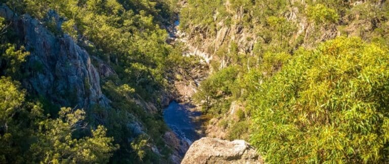
Wander out to Koonin lookout in Crows Nest National Park for a bird's-eye view over Crows Nest Creek, the Valley of Diamonds and distant rolling hills. Look along the way for intricate lichen patterns on rocks, spring-time wildflowers and ant trails in trees.
Be sure to take stop off at Crows Nest Falls lookout along the way to see Crows Nest Creek plunge 20 metres over granite cliffs to waterhole below. Or take the Kauyoo Loop (an additional 600 metres) to visit Kauyoo Pool and the Cascades.
Got some great shots from this hike? Upload your photos here to inspire others and show off the beauty of the trail!
Submitting your photos doesn’t mean you lose ownership. You can be credited for your contributions, and you can request removal at any time.
Please don’t copy GPX files or content from this site to AllTrails or other platforms. Each trail has been personally mapped, documented, and refined to support Australia’s bushwalking and hiking community. While some details come from land managers, every listing reflects significant personal effort. This is a free, community-driven initiative—your respect helps keep it that way.
It looks like I don’t have a GPX file for this trail yet. If you have one to share, please email it to me! I’ll verify it against official maps before adding it to help other hikers have a safer, easier experience. Thanks for contributing to a better hiking resource.
Getting there
Getting to the trailhead: Crows Nest National Park.
Closest towns to this walk: Crows Nest, Hampton, Highfields, Murphys Creek, Ravensbourne, Toowoomba
About the region
Crows Nest is a national park on the Darling Downs of southern Queensland, Australia. It is divided into a number of section which are in both Crows Nest and Grapetree, 40 km west of Esk in the South East Queensland bioregion. A 236 ha national park was first declared in 1967. The park has been extended south along the Great Dividing Range and now covers 17.9 km2 (6.91 sq mi).
The geology of the area is dominated by granites with domed outcrops. The vegetation in the park is mostly open eucalypt forest. Species such as the hoop pine, weeping bottlebrush, river she-oak and swamp mahogany can be found along creek banks. The main watercourse in the park is Crows Nest Creek, a tributary of Cressbrook Creek, itself a tributary of the Brisbane River. About 4% of the park is riverine wetlands.
Crows Nest is known for its rugged landscape, waterfalls, and a sparkling gorge called Valley of Diamonds. This valley is so-called because of the mineral felspar which glistens in the sunlight. Lookouts, wildflower heaths, wildlife observing and birdwatching are popular attractions for visitors. A total of 10 rare or threatened species have been identified in Crows Nest National Park.
For more information on this hiking trail, please visit Queensland.com
Similar walks nearby
Looking for more walks in or near Crows Nest National Park? Try these trails with a similar difficulty grade.
Favourite

Favourite

Ravensbourne National Park
Favourite

Ravensbourne National Park
Favourite

Track grade
Grade 3 (Moderate) - Walks for Most Fitness Levels: Grade 3 on the
AWTGS represents moderate walking tracks. These are ideal for walkers with some fitness who are comfortable with some hills and uneven terrain. While suitable for most ages, some bushwalking experience is recommended to ensure a safe and enjoyable experience. Tracks may have short, steep hill sections, a rough surface, and many steps. The total distance of a Grade 3 walk can be up to 20 kilometers.
Explore safe
Plan ahead and hike safely! Carry enough water, pack layers for changing conditions, and bring safety gear like a torch, PLB, and reliable communication device. Check official sources for trail updates, closures, and access requirements, and review local weather and bushfire advice. Most importantly, share your plans with someone before you go. Being prepared makes for a safer and more enjoyable hike! Stay Safe, Explore More, and Always #ExploreSafe.
Packing checklists
What you carry in your pack depends on factors like weather, terrain, and your adventure type. Not sure what to bring? My free planning, food, and packing checklists are a great starting point, covering day hikes, overnight trips, and multi-day adventures. Use them to customise your kit and always prioritise safety.
Let someone know
Before heading out, take a moment to fill out your trip intentions form. It’s a quick way to share your hike details with family or friends. If something goes wrong, they can notify emergency services, ensuring a faster response and peace of mind. Stay safe and enjoy your adventure
Suggest an edit
Spotted a change on this trail? Maybe there are new features, the route has shifted, or the trail is permanently closed. Whatever the update, I’d love your input. Your feedback helps fellow hikers stay informed and ensures that our trail info stays fresh and reliable.


