Trail Fast Facts
Summit Loop Nature Trail is a 1km, grade 2 hike in Mount Lawson State Park, Victoria. This hike typically takes 30 minutes to complete.
Hike Overview
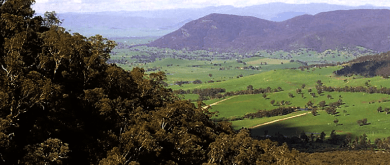
This short nature trail from the picnic area at the Mount Lawson Summit meanders over and around the interesting rock outcrops on the 1,041m peak. Take in the views from various vantage points north to the Murray River valley, south to the Victorian Alps and east to the NSW Snowy Mountains
Track Grade
Grade 2 (Easy) - A Gentle Introduction to Inclines: Grade 2 on the AWTGS represents easy walking tracks that offer a slightly more challenging experience compared to Grade 1. Similar to Grade 1, no prior bushwalking experience is required. The track surface is typically hardened or compacted and may have gentle hill sections or occasional steps. The total distance of a Grade 2 walk is typically no greater than 10 kilometers. These walks are still suitable for families with a bit more experience or those seeking a gentle introduction to some inclines.
Tips
When setting out for a walk, please be prepared:
- Weather conditions can change rapidly at any time be prepared with warm, waterproof clothing and high energy food supplies.
- Tracks can be steep, rough and slippery wear sturdy footwear.
- The park has limited permanent water sources carry adequate drinking water when walking.
- Abandoned mine shafts exist in some areas take care if walking off track.
- Be alert near cliff edges and look out for falling rocks.
- Remote walking tracks may be poorly defined carry an adequate map and compass or GPS.
Map and GPX file
Help fellow hikers navigate with confidence. Share your GPX or KML file for this trail and help build a more comprehensive resource with precise waypoints and elevation profiles. Your contribution will empower adventurers with details they need for a safer and more enjoyable experience. I meticulously verify every file using official maps and surveys, ensuring the highest level of accuracy and reliability. Submit your file now and become a trailblazer for your fellow outdoor enthusiasts.
Trail Location (trailhead)
Sorry, no records were found. Please adjust your search criteria and try again.
Sorry, unable to load the Maps API.
Getting there
Mount Lawson State Park is located about 70km east of Albury-Wodonga. It lies between the Murray Valley Highway and the Murray River. Mt Lawson Road provides unsealed, fine weather, two wheel drive access to most popular visitor areas. Vehicle access to the northern part of the park is possible at The Kurrajongs.
Photo gallery
If you have any photos from this hike and are happy to share them, please upload your .jpg files here.
Please note: Uploading photos does not transfer ownership of copyright away from you. If requested, you will be credited for any photos you provide and can ask they be deleted at any time.
About the region
Mount Lawson State Park has much to offer to keen hikers, with a network of short and medium-length walking tracks leading to spectacular lookouts, rushing waterfalls and shady glades.
Mount Lawson State Park is a haven of wilderness. The unique environment makes it a vital conservation site, home to rare species of plant and animal life.
The park has much to offer to keen hikers, with a number of short and medium-length walking tracks leading to spectacular lookouts and water features within rocky incised creeks.
In spring, wander among the brilliant displays of native wildflowers that blanket the area. You can find nearly 300 native plant species here, including numerous rare species. On the high slopes of the park, you can stride through open forests of Narrow-leaf Peppermint, Candlebark, Manna Gum, Blue Gum and Brittle Gum. Red Stringybark and Long-leaf box dominate the lower slopes along with Red Box and Broad-leaf Peppermint. The steep, dry, northern slopes of the park contain large areas of Black Cypress-pine and Kurrajong.
While you're there, see if you can spot native animal species including the Eastern Grey Kangaroo, Red-neck and Black Wallaby and Common Wombat. You might even see the Barking Owl, a rare species in Victoria, along with many other species of birds.
Similar trails nearby
Explore Safe
While planning your hike, it’s important to check official government sources for updated information, temporary closures and trail access requirements. Before hitting the trail, check local weather and bushfire advice for planned burns and bushfire warnings and let someone know before you go. Plan ahead and hike safely.
Let someone know
Adventure with peace of mind: Fill out your trip intentions form. Before you hit the trail, fill out an online form to privately send important details about your hike to your family or friends. If you don’t return on time, they can easily alert emergency services, preventing worry and ensuring a swift response. Hike with peace of mind and enjoy your outdoor adventure to the fullest. Be smart, be safe: Register your plans here.
Gear to consider
What you carry in your pack will depend on the weather, terrain, time of year, type of adventure, and personal preferences. Having trouble deciding what gear’s right for you? My free planning, food and packing checklists provide an introduction to things your could consider (as well as the Ten Essentials) on your day, overnight and multi-day adventures. Customise your kit according to your personal needs, always considering safety first.
Suggest an edit
Trail changed? New features discovered? Has the route changed? Trail permanently closed? Help fellow hikers by suggesting edits! Click above to update route descriptions, GPX file, trail features (like boardwalks), or access conditions (like parking availability). Help me keep the trails info fresh!
Weather
Acknowledgement of Country
Trail Hiking Australia acknowledges the Traditional Owners of the lands on which we hike and pay respects to their Elders, past and present, and we acknowledge the First Nations people of other communities who may be here today.


