Trail Fast Facts
Sandridge Railway Trail is a 5km, grade 2 hike in Melbourne Region, Victoria. This hike typically takes 1.75 hours to complete.
Hike Overview
The trail follows the route of Australia's first steam railway from Port Melbourne (Sandridge) to Flinders Street Station.
Details on brochure from Museum of Victoria site
Start at the Elizabeth St end of Flinders Street Station. The pedestrian subway leads to the north bank of the Yarra River, where a promenade leads along the bank to former Sandridge railway bridge, which once carried the railway over the Yarra. It is now converted for pedestrian use. Cross the river and continue along the south bank to Clarendon St/Spencer St. Turn left and follow Clarendon St. to Normanby St.
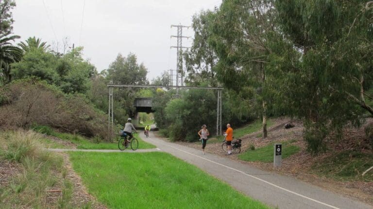
Here a shared path starts following the light railway to Port Melbourne. For much of the route, this path runs through pleasant parkland. The path finishes at the old Port Melbourne Station. From here you can walk on to historic Station Pier.
Track Grade
Grade 2 (Easy) - A Gentle Introduction to Inclines: Grade 2 on the AWTGS represents easy walking tracks that offer a slightly more challenging experience compared to Grade 1. Similar to Grade 1, no prior bushwalking experience is required. The track surface is typically hardened or compacted and may have gentle hill sections or occasional steps. The total distance of a Grade 2 walk is typically no greater than 10 kilometers. These walks are still suitable for families with a bit more experience or those seeking a gentle introduction to some inclines.
Tips
Flinders Street Station to Port Melbourne in Melbourne Region
Melbourne City to Port Melbourne, 1km from Melbourne
Sealed
Flat
Photo credit: Rail Trails Australia. For more information and a location map please visit RailTrails Australia.
Map and GPX file
Help fellow hikers navigate with confidence. Share your GPX or KML file for this trail and help build a more comprehensive resource with precise waypoints and elevation profiles. Your contribution will empower adventurers with details they need for a safer and more enjoyable experience. I meticulously verify every file using official maps and surveys, ensuring the highest level of accuracy and reliability. Submit your file now and become a trailblazer for your fellow outdoor enthusiasts.
Trail Location (trailhead)
Sorry, no records were found. Please adjust your search criteria and try again.
Sorry, unable to load the Maps API.
Photo gallery
If you have any photos from this hike and are happy to share them, please upload your .jpg files here.
Please note: Uploading photos does not transfer ownership of copyright away from you. If requested, you will be credited for any photos you provide and can ask they be deleted at any time.
About the region
The railway was opened 1854 to connect the city to its port. In the 1940s displaced persons were carried by train direct from Station Pier to Bonegilla Station, now part of the High Country Rail Trail.
Similar trails nearby
Explore Safe
While planning your hike, it’s important to check official government sources for updated information, temporary closures and trail access requirements. Before hitting the trail, check local weather and bushfire advice for planned burns and bushfire warnings and let someone know before you go. Plan ahead and hike safely.
Let someone know
Adventure with peace of mind: Fill out your trip intentions form. Before you hit the trail, fill out an online form to privately send important details about your hike to your family or friends. If you don’t return on time, they can easily alert emergency services, preventing worry and ensuring a swift response. Hike with peace of mind and enjoy your outdoor adventure to the fullest. Be smart, be safe: Register your plans here.
Gear to consider
What you carry in your pack will depend on the weather, terrain, time of year, type of adventure, and personal preferences. Having trouble deciding what gear’s right for you? My free planning, food and packing checklists provide an introduction to things your could consider (as well as the Ten Essentials) on your day, overnight and multi-day adventures. Customise your kit according to your personal needs, always considering safety first.
Suggest an edit
Trail changed? New features discovered? Has the route changed? Trail permanently closed? Help fellow hikers by suggesting edits! Click above to update route descriptions, GPX file, trail features (like boardwalks), or access conditions (like parking availability). Help me keep the trails info fresh!
Weather
Acknowledgement of Country
Trail Hiking Australia acknowledges the Traditional Owners of the lands on which we hike and pay respects to their Elders, past and present, and we acknowledge the First Nations people of other communities who may be here today.


