Trail Fast Facts
Randell Park Reserve Circuit is a 4.5km, grade 3 hike in Randell Park Reserve, South Australia. This hike typically takes 1.5 hours to complete.
Hike Overview
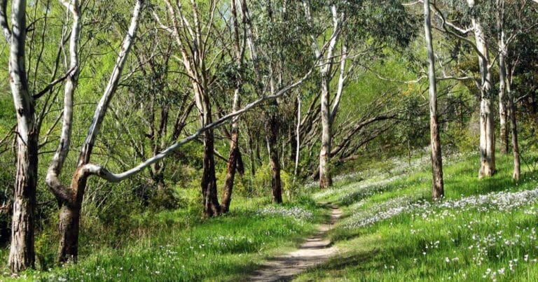
Randell Park Reserve's diverse terrain is best explored on foot. One option for walkers is a moderately difficult (grade 3) 4.5-kilometre loop trail. This scenic circuit takes approximately 1.5 hours to complete and winds its way past the park's geological highlights, including disused quarry faces. Be sure to keep an eye out for interesting rock formations like ripple rock and ochre deposits, as well as the dramatic quarry cliffs. The trail also delves into areas rich with native vegetation, offering a chance to spot Grey Box eucalypts, Drooping Sheoaks, and bursts of Golden Wattle.
While there are a range of possible walking tracks within Randell Park Reserve, this route provides a good overview of the park's natural beauty and historical significance. Remember that trails can become overgrown during spring, so be sure to wear appropriate footwear and clothing. There are also no facilities within the park, so bring plenty of water and any supplies you might need for your walk.
Track Grade
Grade 3 (Moderate) - Walks for Most Fitness Levels: Grade 3 on the AWTGS represents moderate walking tracks. These are ideal for walkers with some fitness who are comfortable with some hills and uneven terrain. While suitable for most ages, some bushwalking experience is recommended to ensure a safe and enjoyable experience. Tracks may have short, steep hill sections, a rough surface, and many steps. The total distance of a Grade 3 walk can be up to 20 kilometers.
Map and GPX file
Max elevation: 257 m
Min elevation: 136 m
Total climbing: 155 m
Total descent: -50 m
Trail Location (trailhead)
Sorry, no records were found. Please adjust your search criteria and try again.
Sorry, unable to load the Maps API.
Photo gallery
If you have any photos from this hike and are happy to share them, please upload your .jpg files here.
Please note: Uploading photos does not transfer ownership of copyright away from you. If requested, you will be credited for any photos you provide and can ask they be deleted at any time.
About the region
Situated near Torrens Park in Mitcham, Randell Park Reserve offers a welcome escape for walkers, cyclists and nature enthusiasts. Bounded by Parkers Road and Andersons Avenue to the west, Brownhill Creek Reserve to the east, Old Belair Road and James Road to the south, and Weemala Drive and Mitcham Cemetery to the north, the park provides a convenient green space for nearby residents.
This sprawling reserve boasts nine kilometres of shared walking and cycling trails that meander through the natural landscape. Open during daylight hours (excluding Total Fire Ban days), these trails cater to a range of fitness levels and offer opportunities to explore the park's diverse geology and vegetation. Several trails lead visitors past the fascinating remnants of the park's past - disused quarry faces. Here, you can marvel at the exposed geological features, including ripple rock, ochre deposits, and the dramatic quarry cliffs. Look closely and you might spot evidence of the interbedded felspathic quartzite, siltstone, shale, slate and freestone that make up the park's foundation.
Beyond the historical significance, Randell Park is a haven for native flora. The park flourishes with indigenous vegetation, including Grey Box eucalypts, Drooping Sheoaks and bursts of Golden Wattle. This diverse plant life provides a habitat for a range of wildlife, making it a great spot for nature observation.
Randell Park is named after Peter Lake Randell, a former mayor of Mitcham who served from 1968 to 1971. The park's namesake reflects the significant role it plays in providing a recreational space for the local community. Whether you're seeking a leisurely stroll, a challenging bike ride, or simply a chance to connect with nature, Randell Park Reserve offers a tranquil escape in the heart of Mitcham.
Similar trails nearby
Explore Safe
While planning your hike, it’s important to check official government sources for updated information, temporary closures and trail access requirements. Before hitting the trail, check local weather and bushfire advice for planned burns and bushfire warnings and let someone know before you go. Plan ahead and hike safely.
Let someone know
Adventure with peace of mind: Fill out your trip intentions form. Before you hit the trail, fill out an online form to privately send important details about your hike to your family or friends. If you don’t return on time, they can easily alert emergency services, preventing worry and ensuring a swift response. Hike with peace of mind and enjoy your outdoor adventure to the fullest. Be smart, be safe: Register your plans here.
Gear to consider
What you carry in your pack will depend on the weather, terrain, time of year, type of adventure, and personal preferences. Having trouble deciding what gear’s right for you? My free planning, food and packing checklists provide an introduction to things your could consider (as well as the Ten Essentials) on your day, overnight and multi-day adventures. Customise your kit according to your personal needs, always considering safety first.
Suggest an edit
Trail changed? New features discovered? Has the route changed? Trail permanently closed? Help fellow hikers by suggesting edits! Click above to update route descriptions, GPX file, trail features (like boardwalks), or access conditions (like parking availability). Help me keep the trails info fresh!
Weather
Acknowledgement of Country
Trail Hiking Australia acknowledges the Traditional Owners of the lands on which we hike and pay respects to their Elders, past and present, and we acknowledge the First Nations people of other communities who may be here today.


