The Bluff via Link Track is a 25.7km, grade 5 hike located in Alpine National Park, Victoria. The hike should take around 2 days to complete.
Hike overview
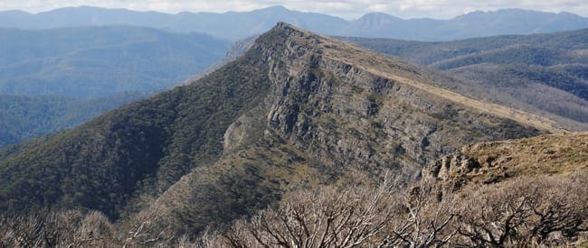
The The Bluff via Link Track hike commences from a pleasant grassy clearing beside the Howqua River. The trail climbs steadily through dry open forest along Eight Mile Spur. The final stages of the ascent to the rugged natural ramparts of the Bluff are quite steep, but the rewards are soon evident. From the treeless 1,725 metre summit a spectacular alpine panorama unfolds, stretching to Mount Buller in the north and faraway Lake Eildon.
The trail continues through alpine meadows, carpeted with brilliant wildflowers in early summer, to Bluff Hut and a sheltered campsite among the nearby snow gums. Next morning, descend along a 4WD road on Sixteen Mile Spur for approximately two kilometres then locate a barely visible foot trail that descends along a steady spur to the Ritchies Hut on Howqua River.
From the hut, follow the river valley in a westerly direction to the start of the trail at Eight Mile Flat. Along this final section of the hike you will have the option of following either the high or low track. Both are equally as enjoyable so pick the best track for the conditions. Low track requires several wide and often deep river crossings.
Day 1 (13km)
Camp at Bluff Hut. Water should be available at this location.
Day 2 (12.7km)
Return to the trail head. Water will be available at Ritchies Hut and at various points along the Howqua River.
Best time
Summer, Autumn
All hikers should realise that weather conditions can change rapidly in alpine areas at any time of year. Snowfalls can be experienced at any time, so please be prepared with:
- warm clothing
- windproof and waterproof jacket
- gloves and hat
- strong footwear
- energy food and water
- compass and relevant topographical map
Route and GPX file
Max elevation: 1718 m
Min elevation: 565 m
Total climbing: 1800 m
Total descent: -1800 m
Trail location
Sorry, no records were found. Please adjust your search criteria and try again.
Sorry, unable to load the Maps API.
Getting there
Travel to Mansfield from Melbourne (195km) and Take the Mount Buller Road for 20.6km, turn right onto Howqua Track and travel for 16.4 km to Sheepyard Flats. Drive through Sheepyard Flats and continue along Brocks Road for 13km to 8 Mile Flat. Turn left at the junction and continue to the carpark at the end of the track.
Access conditions
- 2WD Access
- Gravel Road
- Steep Road
- Public Toilets
- Untreated Water
- Campfire Pit
- Camping Area
About the region
The Alpine National Park is a national park located in the Central Highlands and Alpine regions of Victoria, Australia. The 646,000-hectare national park is located northeast of Melbourne. It is the largest National Park in Victoria, and covers much of the higher areas of the Great Dividing Range in Victoria, including Victoria's highest point, Mount Bogong at 1,986 metres and the associated subalpine woodland and grassland of the Bogong High Plains. The park's north-eastern boundary is along the border with New South Wales, where it abuts the Kosciuszko National Park.
Similar trails nearby
Explore Safe
While planning your hike, it’s important to check official government sources for updated information, temporary closures and trail access requirements. Before hitting the trail, check local weather and bushfire advice for planned burns and bushfire warnings and let someone know before you go. Plan ahead and hike safely.
Let someone know
Adventure with peace of mind: Fill out your trip intentions form. Before you hit the trail, fill out an online form to privately send important details about your hike to your family or friends. If you don’t return on time, they can easily alert emergency services, preventing worry and ensuring a swift response. Hike with peace of mind and enjoy your outdoor adventure to the fullest. Be smart, be safe: Register your plans here.
Gear to consider

My free planning, food and packing checklists provide an introduction to things your could consider (as well as the Ten Essentials) on your day, overnight and multi-day adventures. Customise your kit according to your personal needs, always considering safety first.
Suggest an edit
Does this hikes information need updating? Sometimes the route, trail features or access conditions change.
Acknowledgement of Country
Trail Hiking Australia acknowledges the Traditional Owners of the lands on which we hike and pay respects to their Elders, past and present, and we acknowledge the First Nations people of other communities who may be here today.


2 Reviews on “The Bluff: Link Track (25.7km)”
I did this one a couple of years ago, so take some of this information with a grain of salt.
Depending on how quickly you can hike, you probably want to leave 8 Mile Flat at around 8 to 9 AM. If you hike at the same pace as me, this should get you to Bluff Hut around 5 to 6 PM. The initial hike up 8 Mile Spur will be steep (although nothing compared to the climb up to the Bluff) so be prepared.
At the time, the last part of the track coming back down the 8 Mile Spur Track into Refrigerator Gap was overgrown and difficult to follow. Make sure you have a compass and map on you so that you can navigate in the bush to Bluff Link Rd if need be. Refrigerator Gap is also an excellent spot to rest and recharge prior to making the climb up to Bluff Hut. There’s 4WD access for those hiking with support, and plenty of open space and shade to sit around and enjoy lunch.
In addition, please pay attention to the conditions. The map I had noted that the upper section of the climb up to the Bluff gets slippery when wet, so take care. I fortunately had excellent conditions at the time so the grip was good. Either way, be prepared to scramble over rocks in places. The climb is very steep, and I couldn’t see many places where there were easier alternate routes. I would second Hugh’s advice on getting your pack as light as you can.
The hike from the Bluff to Bluff Hut is pretty straightforward. Just take care if you decide to walk along the ridge rather than the trail itself. The vegetation is dense in spots, and it’s probably best to stick to the trial any way to avoid damaging any of it.
The notes above mentioned that the 14 Mile Spur track was hard to spot. When I went, there was the occaisional flag marking the track out including it’s start near Bluff Link Rd, but there was an event on nearby, and that may have been from the event so be prepared to find it the hard way. Once you are on it, however, it was pretty easy to follow. The final descent down into Ritchies Hut is also surrounded by vegetation, so long sleeves and pants are a must. A stick to brush away spider webs is also highly advised so that you don’t end up with a face full of spider.
I took the Low Track back to 8 Mile Flat, and it is so refreshing on a hot day to walk through the Howqua River at all of the crossings. Just keep an eye out on snakes, I saw at least three of them on my way through.
There is good reception for the most part along the route, thanks to Mt Buller being just across the valley. However, the usual advice applies: Don’t rely on your phone. If you are going to camp at 8 Mile Flat, the 4WD track isn’t open year-round I don’t think, and even in a decent All-Wheel Drive (Hyundai Santa Fe) I still had trouble getting out due to how steep one section of the track was and the dusty condition of the track. I think it took me three attempts to get out of there. DON’T try to get in there with a 2WD, you’re probably not getting back out.
There are also log books at both Ritchies Hut and Bluff Hut. Sign them on your way through, and happy hiking!
Walked/fastpacked this trail this weekend (26-27/11/22) and Bluff’s Hut water tank was full, and that was before the 5mm of rain we got on Saturday night. FYI the tank is about 500L.
Some parts of the track are a bit boggy, and because of the recent weather, there’s a few water crossings you have to do once down on the river.
Oh and the rock scrambling to get up to the Bluff Summit (if going anti-clockwise) is doable if you take your time. Would recommend getting your pack as light as possible though.
This was one of the best and most intense hikes I’ve done. Echoing what others have said, the climb up 8 mile spur is brutal, unrelenting uphill the whole day. But it makes the view once you get up on top of the bluff that much more spectacular. We saw no reliable water source after 8 Mile Flat and carried about 4litres each for the day. There was a half full water tank at Bluff Hut when we went in March 2020. Plenty of camping near Bluff Hut and just up the road a short ways. The next day coming down 14 Mile Spur was fine, it was overgrown for much of it (but there were some pink markers, so maybe its been maintained since then) and finding the trail from the 4wd track was a bit tricky, some large tree trunks had been placed at the start of the trail, so keep a close eye on your GPS when you get to the zigzag section of the 4wd track. Once you get down to Ritchies Hut (another great hut/campsite) theres plenty of water in the river. Two options to get back to 8 Mile Flat are the high and low tracks, on a hot day the low track with all the river crossings might be quite pleasant – but slower going. The high track was very exposed and you’re walking along some quite steep cliffs, also looked like prime snake territory and we saw 3-4 snake sized lizards that really made us jump – so take care along this section! All in all a fantastic hike, I’d say the best one in 2020!
Such an awesome hike. Particularly in the snow
Leisa Meyer this looks like a good one as well.
Loved this hike! Did the circuit (Nov 17) in 10hrs as part of Hut2Hut training. The Bluff climb is brutal but the views from the top stunning! There are a couple of large trees down across the entrance to 14 mile spur making the trail head pretty obvious, but the rest of the trail is very narrow and difficult to see at times (particularly with rain laden Myrtle closing in on you!)